The wildfires in California, which have been terrible, may be brought to an end in the next few days when a storm arrives over the weekend and drenches the area, which has been historically dry. However, the storm may also bring about a different problem: flash floods.
Flood watch signals have been issued in the same neighborhoods of Los Angeles that were destroyed by the blazes that started this month. These fires were fueled by hurricane-force winds after a record-breaking dry spell of over seven months in portions of Southern California.
Beginning at 4 p.m. on Sunday, the 24-hour flood watch alerts will cover the still-active Palisades Fire, which has burned 23,448 acres and is 79% contained, as well as the Eaton Fire, which has scorched 14,021 acres and is 95% controlled.
According to the National Weather Service, the watches were issued because of the likelihood of mudslides, which means that conditions are favorable for flooding but not imminent. According to federal forecasters, there is a 10% to 20% chance of major flooding and debris flow.
“While damaging debris flows are not the most likely outcome, there is still a lot of uncertainty with this storm,” the weather service office in Oxnard stated on Friday. “The threat is high enough to prepare for the worst-case scenario.”
Flood watches were also in effect for the Bridge Fire in September, which left a burn scar above the San Gabriel Valley in the Angeles National Forest, and the Hughes Fire, which began earlier this week and has burned 10,396 acres in the forest northwest of Los Angeles. As of Friday, the fire was 79% contained.
Residents who wish to be ready for the potential of mudflows can get sandbags from Los Angeles County and communities including Baldwin Park, Pasadena, and Los Angeles.
A weather service prediction discussion indicated that rain might begin to occur in Los Angeles County on Saturday afternoon and intensify on Sunday, with “moderate to locally heavy rain and small hail or graupel” possible.
Forecasters predicted that up to an inch of rain might fall in San Diego and a quarter of an inch in urban Los Angeles. According to them, Sunday might be the wettest day.
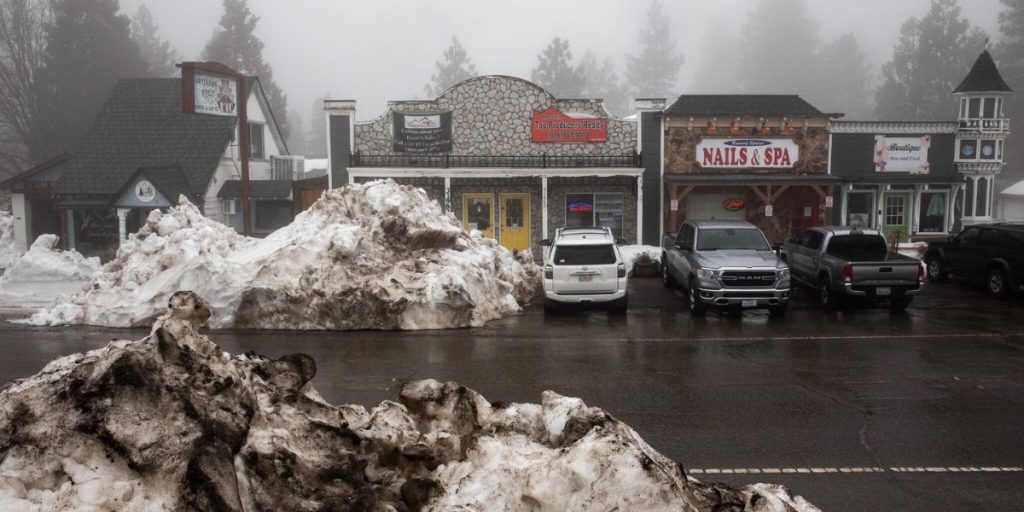
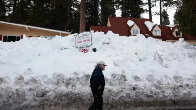
Winter storm warnings for the San Gabriel and San Bernardino ranges have been prompted by the anticipated snowfall in Southern California mountains and their villages, including Wrightwood, Big Bear City, Big Bear Lake, Crestline, Running Springs, and Lake Arrowhead.
At 4 p.m. on Sunday, the 48-hour warnings are scheduled to begin.
According to the meteorological service, from Saturday afternoon through Monday afternoon, up to 18 inches of snow might fall above 6,000 feet, with up to 6 inches likely above 4,000 feet.
In a forecast discussion, the Oxnard weather service office warned that a “dusting” of snow might reach 1 to 2 inches along the Grapevine in the Lebec section of the crucial 5 freeway, which connects the U.S. borders with Mexico and Canada.
According to the office, there was a chance of travel delays.
Hillcrest Rd. Closure Sparks Frustration as DART Silver Line Construction Delays Continue
Snow accumulations of up to 14 inches and 8 inches, respectively, were even possible in the mountains of San Diego and urban Los Angeles counties.
According to the forecast, the San Diego County Border 2 fire has burnt 6,273 acres since Thursday and is 10% contained as of Friday night.
Only on January 10th, according to the San Diego weather service office.It was the driest winter since 1860, when meteorological records began to be kept, with 14 inches of rain falling since the water year began on October 1.
Forecasters predict that temperatures in southern California will drop by 10 to 15 degrees during the weekend.